Waheed Odubayo

Software engineer · Product builder

I build software that turns messy real-world data into decisions.

Shipping production software since 2003 — now building products for households, cities, and coastlines.

Products

What I’m building

Two prototypes, two very different kinds of data — a household’s pantry and a city’s floodplain.

AndroidPrototype

Grocr — groceries, in sync

Grocr keeps a household’s food in sync. Families, housemates, and friend groups share live shopping lists and a common pantry — so nobody double-buys, forgets the milk, or finds something expired at the back of the shelf.

Working today

  • Live shared lists — multiple people shopping at once, with who bought what, where, and for how much
  • Reusable buddy groups for households, events, and friends
  • Pantry inventory with stock levels, expiry alerts, and calorie estimates (Open Food Facts)
  • Scan to add — photograph a typed or handwritten list to transcribe it, or a receipt to match purchases to list items
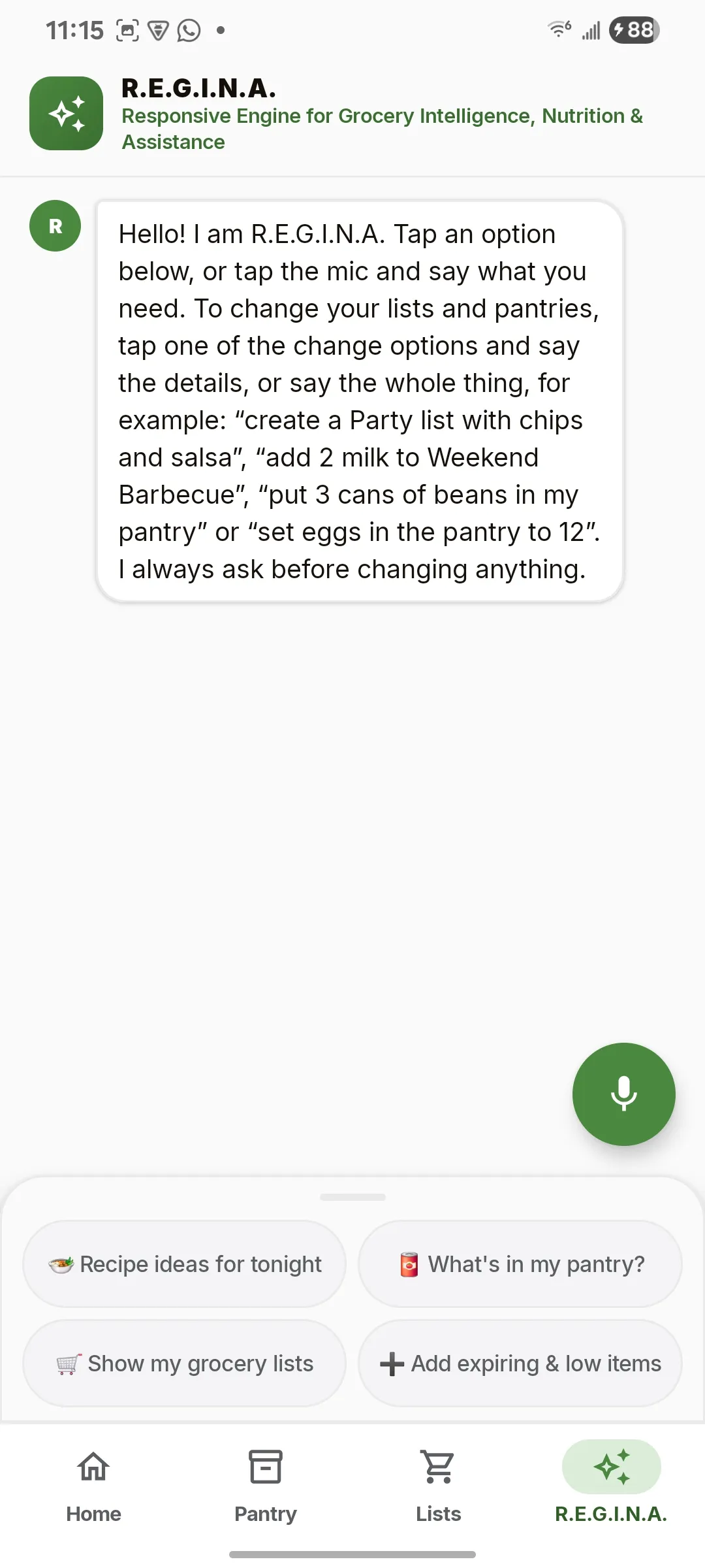
  • R.E.G.I.N.A., a voice and text assistant: “add 2 milk to Weekend Barbecue.” Always confirms before changing anything.

Next

  • Recipe suggestions from what’s already in the pantry
  • Play Store release

Built with

  • Kotlin
  • Jetpack Compose
  • Firebase
  • Supabase
  • WebSockets
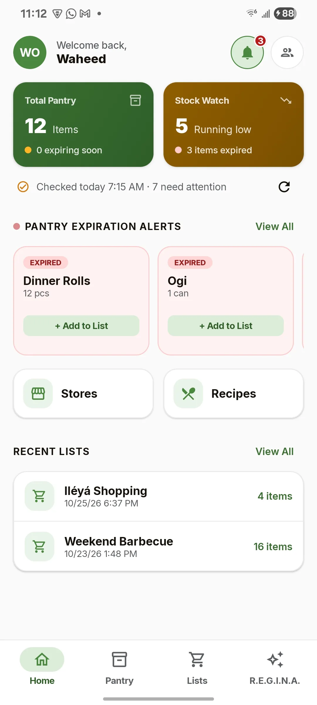
  • Grocr home screen with pantry totals, stock watch and expiration alerts

    Home

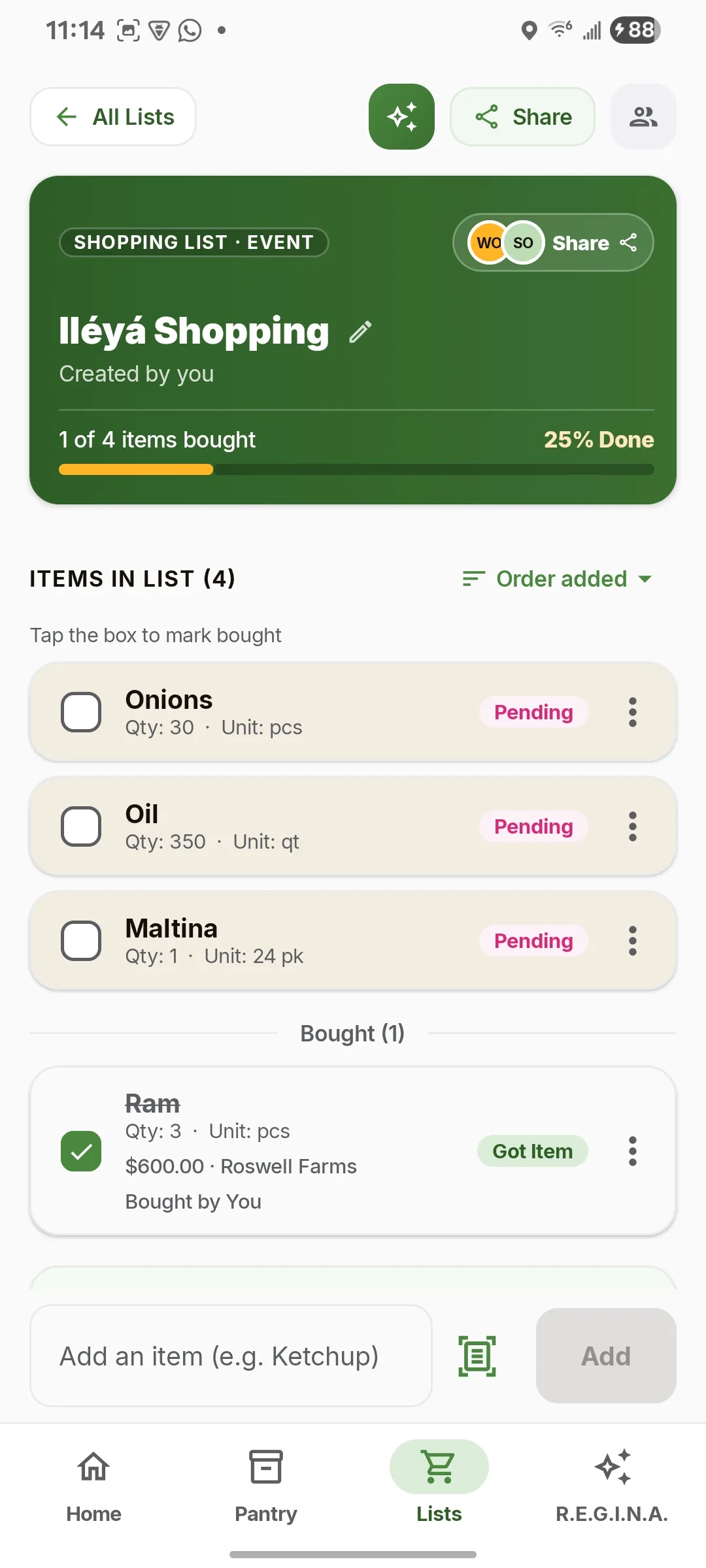
  • A shared event shopping list showing items pending and bought, with price and store

    Shared list

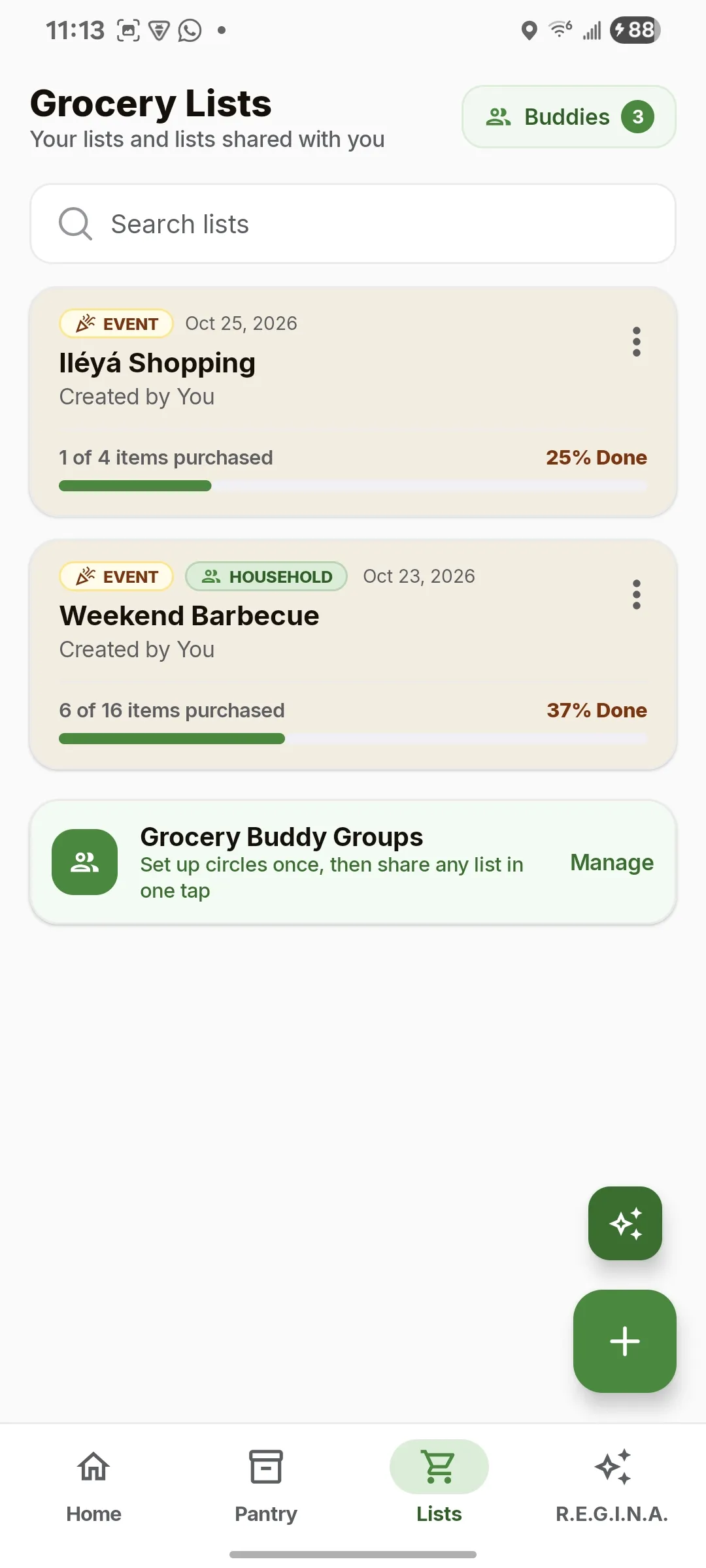
  • Grocery lists screen showing event and household lists with progress

    Lists

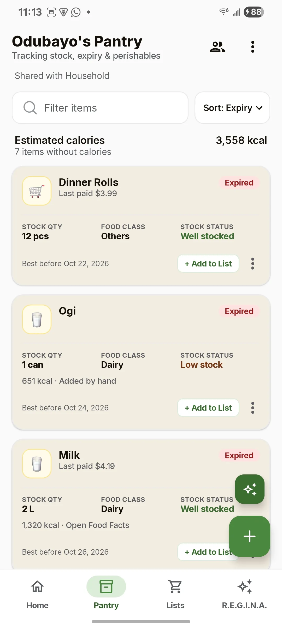
  • Pantry screen with stock levels, food class, expiry dates and calorie estimate

    Pantry

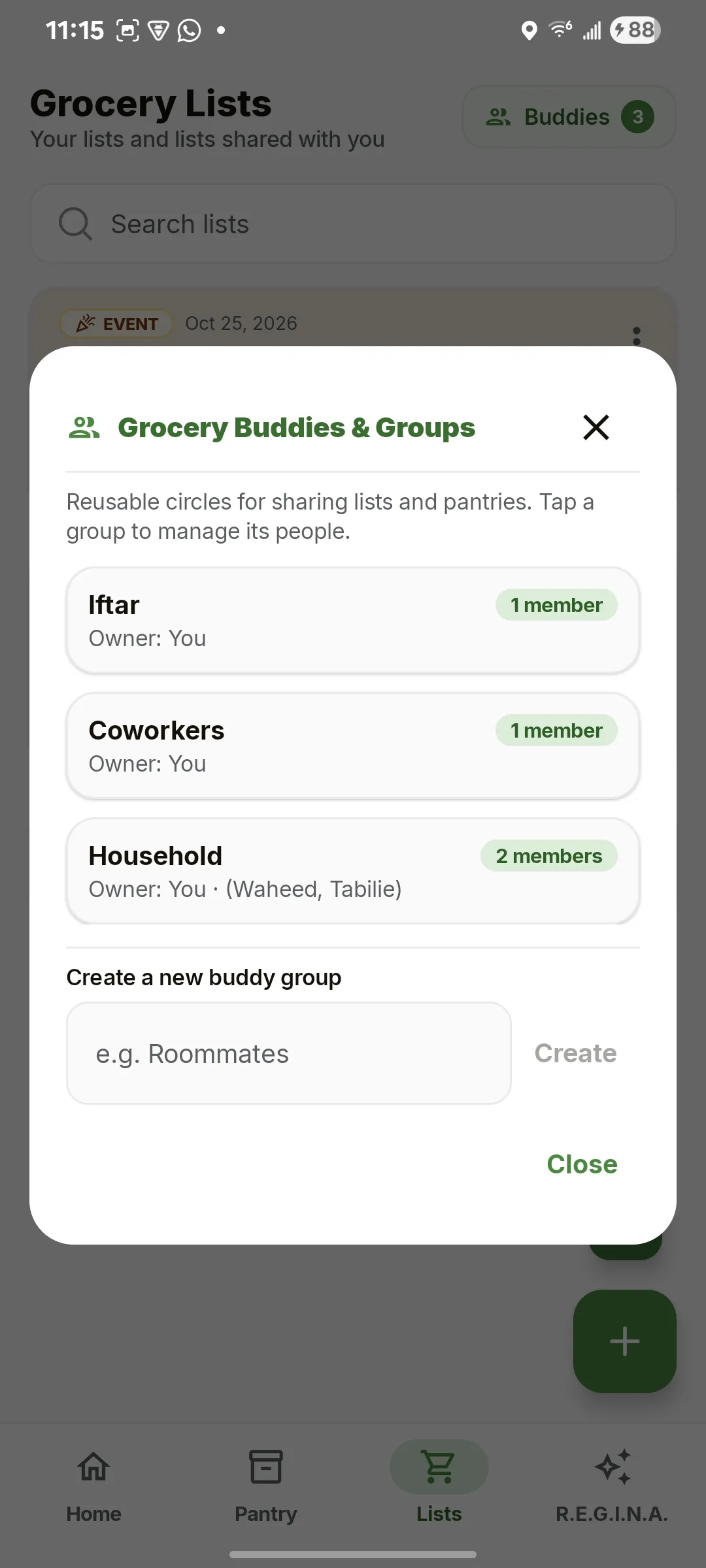
  • Grocery buddy groups dialog with Household, Coworkers and Iftar groups

    Buddy groups

  • R.E.G.I.N.A. assistant screen with example voice commands and quick actions

    R.E.G.I.N.A.

Geospatial pipelineIn progress

Lagos Flood Intelligence — mapping floods from space

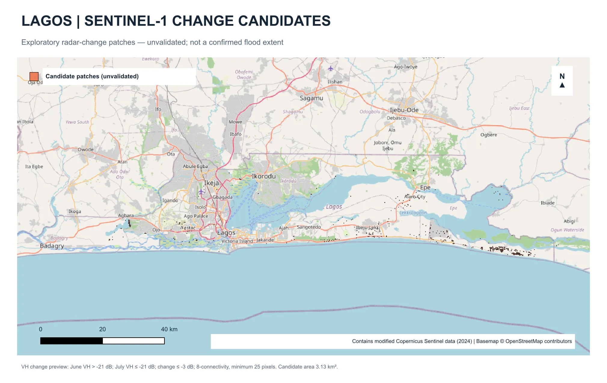
When heavy rain flooded Lagos on 3–4 July 2024, reports came in from Lekki, Ibeju-Lekki and beyond — but no clear map of where the water went. This project builds a reproducible pipeline that compares Sentinel-1 radar imagery from before and after an event to find candidate flooded areas, with the long-term goal of a reusable runbook for any future flood.

Map of the Lagos coast with small candidate patches along the coastline and lagoons
Exploratory Sentinel-1 radar-change candidates (unvalidated), July 2024. Not a confirmed flood extent.

Progress so far

  • Sentinel-1 pair acquired with provenance tracking; preprocessed in ESA SNAP (orbit, calibration, terrain correction)
  • Backscatter change analysis across 71% of the Lagos study area
  • 400 candidate patches (3.13 km²) with radar and terrain review attributes
  • Validation against independent evidence (NEMA, GDACS, geolocated imagery) under way

Why “candidates,” not “floods”

A darker radar return doesn’t prove flooding. Each patch is reviewed against terrain, historical water, and outside reports before anything is called a flood.

Built with

  • Python
  • GeoPandas
  • ESA SNAP
  • QGIS
  • Sentinel-1/2
  • NASADEM
  • Docker

Applied AI

Computer vision under water

My MSc research: teaching models to find scallops — and measure their habitat — in seafloor imagery.

MSc Oceanography thesis · University of Rhode Island, 2026 · with Rhode Island DEM

Bay Scallop Monitoring with Computer Vision

The problem

Bay scallops in Point Judith Pond, Rhode Island, were once a 100,000+ lb/year fishery; today numbers are too low to sustain one, and decades of restoration have had limited success. Monitoring relies on scuba surveys and manual image review — slow, small-scale, and hard to repeat. And because scallop survival is closely tied to eelgrass, counting scallops without measuring habitat tells only half the story.

What it revealed

Scallops occurred most often in moderate eelgrass cover (30–60%)— less in sparse or dense beds. That fits a balance between protection from predators (lacking in sparse beds) and water exchange and oxygen (reduced in dense ones): habitatdensity matters, not just presence.

What I built

An end-to-end deep learning pipeline that finds scallops and measures the habitat around them, from seafloor imagery collected by an autonomous surface vehicle along RI DEM-selected transects.

  • Detection

    YOLOv5 detector for live scallops — small, camouflaged, often half-buried.

  • Habitat segmentation

    U-Net classifying every pixel as eelgrass or sand/silt, giving each image a habitat composition.

  • Representation learning

    GeoCLR — contrastive learning that uses each image’s GPS position to learn habitat structure from mostly unlabeled imagery.

  • Integration

    Detections merged with habitat masks to analyze where scallops occur relative to habitat.

Engineering decisions

Single-class over multi-class
Live, dead, and face-up shell classes were too sparsely labeled; focusing on live scallops concentrated the model on what matters.
Structured augmentation for underwater light
CLAHE contrast correction, HSV color-space transforms, and rotations to counter strobe hotspots, dark corners, and color loss — applied to training data only.
Spatially independent evaluation
Entire survey lines held out, so results reflect new locations, not memorized ones.
Right-sized models
YOLOv5 generalized better than newer, larger variants on a small, specialized dataset.
Bias mitigation
Identified and corrected systematic eelgrass overestimation from vignetting (15% edge crop) and camera viewing geometry.

Tools

  • Python
  • OpenCV
  • MATLAB
  • CVAT
  • YOLOv5
  • U-Net
  • GeoCLR

Data collected with RI DEM; project led by Dr. Chris Roman, URI Graduate School of Oceanography.

Read the full thesis on DigitalCommons@URI →

Experience

Production engineering since 2003

From financial ledgers in Nigeria to home health software, NASA aircraft operations, and surgical scheduling — and leading the teams that build them.

  1. 2023 – present

    LeanTaaS

    Software Engineer

    Surgical scheduling SaaS. Architecture decisions on core scheduling features; leading client data migrations so hospitals go live on the new platform with their full history.

  2. 2015 – 2019

    NASA (via SAIC)

    Senior Software Engineer

    Aircraft Operations Division (AOD): built and maintained the parts ordering and inventory system that keeps the division’s aircraft supplied, in C# / .NET MVC and AngularJS under CMMI — feature delivery, code and design peer reviews, test plans, and defect resolution.

  3. 2010 – 2014, 2019 – 2023

    Cradle Solution

    Software Engineer → Lead Engineer → Senior Engineer & Team Lead

    Home health management software for home health agencies. Grew from building scalable C#/.NET systems (99%+ uptime), to leading the upgrade to CMS OASIS-C1 (the Medicare home health assessment standard), to running Scrum delivery for onshore and offshore teams while staying hands-on in React, Node, and ArangoDB on AWS.

  4. 2014 – 2015

    Weatherford International

    Software Support Analyst

  5. 2003 – 2004

    Early career, Nigeria

    Software Engineer

    Built a self-balancing sales ledger system for financial accounting.

Stack

  • C# / .NET
  • React
  • Node.js
  • Kotlin / Android
  • MongoDB
  • ArangoDB
  • SQL Server
  • AWS
  • Docker
  • Python
  • OpenCV

Credentials

  • AWS Certified Developer
  • BS Computer Science — UH-Downtown
  • MS Oceanography — University of Rhode Island, 2026